 Northwest Arizona has one of the finest stretches of Old Route 66 to be found anywhere. The stretch is now protected as an "All American Road" and is well signed with U.S. "Historic" 66 markers. Adding additional markers to portions of I-40 in central and eastern Arizona would sew everything together and provide the Route 66 traveler with a seamless, uninterrupted route across the Grand Canyon state and through the West.
 The Grand Canyon State has always had more than its share of attractions for the average traveler and tourist. In addition to the famous gorge itself, there are also Meteor and Sunset craters, the pine-clad Coconino plateau and a large, rich Native North American history and culture. The gods of one tribe of Native North Americans are said to reside in the San Francisco Peaks of which Route 66 passed within a stone's throw.
 Much of this part of the country was originally opened to tourists and settlers alike by the old Atchison, Topeka and Santa Fe Railway whose glistening rails actually predated Route 66. The Railway's famous "Harvey Houses" became well known all over the world for their fine cuisine and havens of rest for weary train travelers.
With the coming of U.S. 66 in the 1920's, the rails and the highway ran parallel for many miles at different locations. Several generations of children were delighted and awed in the back seat of their family car as one of the Railway's crack streamliners or fast freights would rush by outside their window while Dad expertly held his hand to the steering wheel safely guiding them west over U.S. Highway 66.
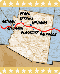
Residents of northwestern Arizona can be proud that they are hosts to what is probably the longest, continuous, pristine stretch of the original Route 66 that still retains its state highway status and is as yet unblemished by a freeway. The old road from near Seligman to just west of Kingman is in excellent condition and maintained by the State DOT as Arizona 66.
In 2005 the entire stretch of Old Route 66 across the northwestern part of the state from just west of Ash Fork to Topock was declared a National Scenic Byway along with several additional, disconnected segments in central and eastern Arizona. In 2009 the status of the Byway was upgraded to "All American Road" Arizona's portion of Old Route 66 is the only part of Route 66 to date (2012) to have achieved this status.
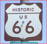
Arizona's Route 66 markers are among the best to be found anywhere. (see state route 66 signage ratings). Not only are they thorough and include MUTCD-like sign assemblies but the very design of the route marker itself is a very pleasing, attractive piece of art work. In fact, it wouldn't be a bad idea if the other Route 66 states would adopt this marker if such a thing were possible.
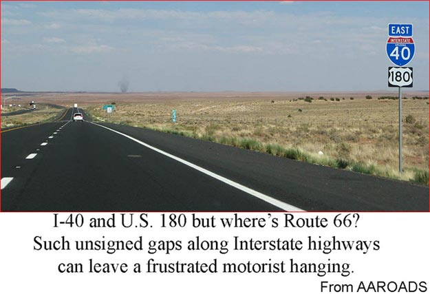
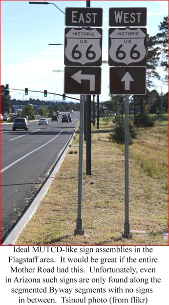 In spite of Arizona's otherwise excellent marking plan, there is unfortunately a fly in the ointment. Arizona has only erected the historic signs along sections of the Route that have been declared as Scenic Byway. East of Ash Fork, the Byway consists of a number of individual, unconnected segments where the Route 66 traveler must enter I-40 to get from one segment to the next. Since the State DOT places no Route 66 markers on I-40, this completely destroys any element of continuity and may even lead to some driver confusion or frustration.
To address this issue, The Route 66 Recommissioning Initiative advocates the restoration of the "66" U.S. Route designation in Arizona along the alignment of the Byway and on I-40 between Byway segments. This would provide the Route 66 traveler with a continuously signed route.
The new U.S. 66 would be required to meet all Byway guidelines and criteria. Ideally, if the U.S. 66 designation could be restored, perhaps the U.S. "Historic" 66 signs could be used throughout the state instead of the conventional black-and-white U.S. route signs. If that creates issues, then both types of markers could be used on the Byway segments with only black-and-white markers placed on I-40.
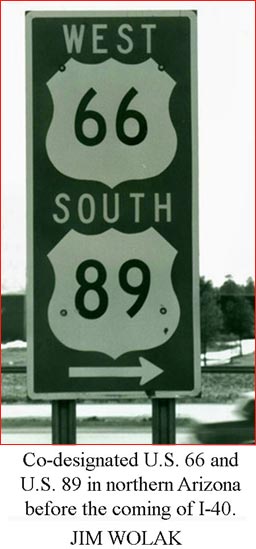
Concerning the placement of Route 66 markers on I-40, it should be noted that several segments of modern day I-40 were built in the early 1960's - especially in eastern Arizona - and carried the joint U.S. 66 and I-40 names for over 20 years before 66 got decommissioned in 1985. That actually constitutes more than one third of the time that Old U.S. 66 even existed! (1926 - 1985).
So new joint signing of I-40 and U.S. 66 together where necessary would not only provide the Route 66 traveler with an improved level of state-to-state continuity but would actually be historically accurate as well.
All U.S. Routes are managed by the American Association of State Highway and Transportation Officials (AASHTO). AASHTO policy clearly states that "Notwithstanding established policies, AASHTO recognizes that Congress on occasion will establish highway routes, specifying the location of the route as well as designating the route number(s) to be used".
Concerned Arizona residents should find and contact that U.S. Representative and let them know that a new U.S. Route designation is needed. Find and contact your Rep at: http://house.gov/writerep/
Additionally, it would help to contact the Arizona DOT and let them know that Route 66 markers are needed on those portions of I-40 where no parallel Byway is available.
Contact the DOT at: https://wwwa.azdot.gov/contact_adot/index.aspx
|